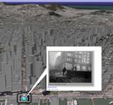
The USGS (US Geological Survey, not the US Genealogical Survey!) and Google have teamed up to provide a virtual tour of the “Great San Francisco Earthquake of 1906”, and it helps put things in perspective. For many genealogists who have done research in regards to that area of California, it’s caused quite a few problems. It’s one of those major events where many important records are lost (not just genealogy-related but historical as well), people are uprooted, people died and were buried in unmarked graves, etc.
You can access it at the USGS site:
The Northern California earthquake of April 18, 1906, commonly referred to as the “Great San Francisco Earthquake of 1906″, is the most damaging earthquake in US history. San Francisco and surrounding cities were violently shaken by seismic waves produced by the magnitude 7.8 earthquake. The remarkable post-earthquake construction and renaissance of the Bay Area are important events in the history of the region. The 1906 earthquake also revealed the existence and significance of the San Andreas fault to earth scientists, who then gave birth to the science of earthquakes. This virtual tour utilizes the geographic interactive software Google Earth to explain the scientific, engineering, and human dimensions of this earthquake, so as to help you visualize and understand the causes and effects of this and future earthquakes.